| Paddlers |
|
| Tony Sandry |
|
| Stew Burdis |
|
| Tudor Grashoff |
|
| Carlos Lopes |
|
Until John Christmas mentioned it on the
forum, I didn’t know that Saturday 21st June was the
date for the annual Round Island Race. According to the
RIR website, the race would be heading towards the
Needles from Cowes, so we wouldn’t have any potential
problems until they reached the home stretch of the
race. Worryingly, on the same website it mentioned that
the lead boats could be home by lunch.
The Round the Island Race
As luck would have it (for us kayakers),
the winds were light, and the race was becalmed for a
time on the SE coast of the island.
Carlos and Tudor, two new club members
based in London, joined Stew and myself for the weekend.
The Met Office had predicted force 3 or less and a
smooth/slight sea, and as a bonus, a cloudless sky. What
a rarity….
We parked the cars only 5 minutes walk
away from Southsea beach and set off to a background of
singing and baptisms taking place in the sea only a few
metres away (bbrrr..).
Baptism anybody?
Our initial bearing took us to
Horse Sand Fort, one of the four Solent forts built in
the 1860’s.The forts were built because of a perceived
threat from the French. They are sometimes known as Palmerston’s Follies, named after Lord Palmerston, who
was The First Lord of the Treasury when the forts were
planned. The forts guns were never fired in anger.
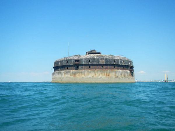
One of the Solent forts
In 2012 Spit Bank was opened as a luxury
holiday facility by ‘Amazing Retreats’. Also in 2012
Horse Sand and No Man’s Land were bought by Clarenco,
and they are due to be converted into a museum and
luxury hotel.
St Helen’s fort is in private hands.
Apart from Brittany, and Condor ferries, and the rare
sighting of a warship, there are a myriad of boats and
ships that use The Solent.
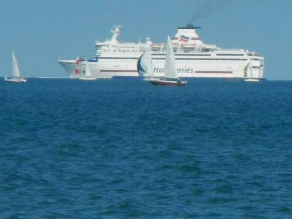
Brittany Ferry
If we paddled between Ryde
and Cowes, hovercraft, fast cats and other more
traditional ferries would be added to the mix. Worst of
all, however, are the ‘gin palaces’ and other assorted
power boats and jet skis as they appear to race
endlessly up and down The Solent. Yachts are large in
number, but whether they are under sail or motor, most
sea kayakers feel that their helmsmen are more likely to
be aware of other boaters. They are also much slower
than powered boats.
Large ships follow a well defined route
that takes them between Horse Sand and No Man’s Land
Forts, so they are relatively easy to avoid. Stuart
Fisher in his book ‘Inshore Britain’ writes “There are
more pleasure craft in The Solent than there are
commercial ships in the whole world so it gets a bit
busy at times”.
We arrived at Bembridge harbour after
about one & a half hours paddling and had a short lunch
break on a rapidly growing sand bank. Whilst we were
there we heard a radio conversation between a group of
jet skiers and the coastguard. There were about thirty
of them setting off for Shoreham and they expected to
take 2 1/2 hours to get there. Pity the poor
kayaker/windsurfer/kite surfer, or yachtsman out for a
pleasant day en-route.
Bembridge has an attractive new RNLI
Station that was completed in 2011 at a cost of
£7,000,000. The boathouse houses a Tamar class all
weather lifeboat and an inshore boat. The concrete and
steel walkway is 250yds long because of the Bembridge
Ledges.
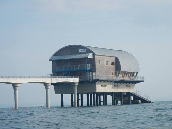
The new Bembridge Lifeboat Station
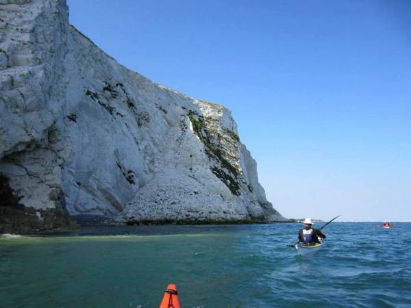
The Bembridge Ledges and Whitecliff Bay
area are an SSSI. The area is important because of the
extensive areas of intertidal sand, rock and shingle
that is being caused by the rapidly eroding cliffs.
The Ledges themselves are of Bembridge
Marls. Bembridge Marls are “shallow marine, estuarine
and freshwater sediments that yield an abundance of
fossils”. They are particularly renowned for the
important fossil mammal faunas and fossil plant floras.’
As it was low tide we had to paddle some distance out to
avoid The Ledges. It was at this point and about 14:00
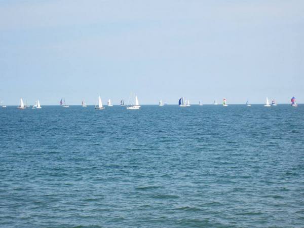
that we saw the vanguard of the huge flotilla that was
‘The-Round -Island –Race’. They were a few miles
offshore and filled Sandown Bay in a seemingly endless
procession of yachts. The yachts continued to process
across the bay in large numbers until about 22:00. By
about 23:00, we saw what we presume was the winner of
the wooden spoon award. I think that the cut-off time
for the circuit was 10 hours; if so, my guess is that
more than half the fleet would have been disqualified.
By mid-afternoon we reached the beach at
Whitecliff Bay and decided to push on to Sandown. Culver
Cliff was dramatic as it had suffered an enormous
collapse several years ago.
Culver Cliff
With a weak tide against us
and a hint of wind we took about 40 minutes to get
there. En-route we passed Red Cliff which I tried to
catch unsuccessfully as a background for a photograph.
Sandown sea front had clearly seen better days. A
ghastly building with a sizable frontage had been
boarded up a few years earlier, and will probably remain
like that for many years before anything useful is built
in its place. The café/bar on the beach terrace served
reasonable coffee although when Carlos asked for a
glass of tap water, the guy behind the bar said they
didn’t have any water. Yes, we know that the IOW is
still trying to enter the 21st century, but no mains
water? We weren’t aware that the island was suffering a
drought so presumed that he was a tight git. We had a
good vantage point for watching the yachts move almost
imperceptibly from West to East, and lounged around for
about an hour.
With the tide in our favour, and well
rested, we made it back to Whitecliff beach by late
afternoon.
“Whitecliff Bay is famous for the well-exposed rock
sequence from the Cretaceous (142-65 million years ago)
Chalk through to the Tertiary (65-2 million years ago)
Bembridge Marls. The beds are vertically inclined,
making it easy to access the complete succession from
beach level”.
The extreme eastern side of the beach
looked the best prospect for camping, and it was also the
furthest away from the track that led up to the caravan
park on the cliff top. We were hard pressed to find any
suitable ground for the four of us, but after 5 minutes
of shovelling shingle a moderately flat platform could
be achieved. I had decided to try out a tarp for
shelter. It worked out fine, but by the time I had
attached lines to it and fixed my splits in place, the
other guys had pitched their tents and were enjoying tea
and biscuits. I had camped here a few years ago and had
told the others that the holiday camp had a small bar, a
shop and a decent showers/toilet block. A burger van had
seemed very popular with some of the paddlers. Carlos
and Tudor strolled up and came back laden with food and
drink.
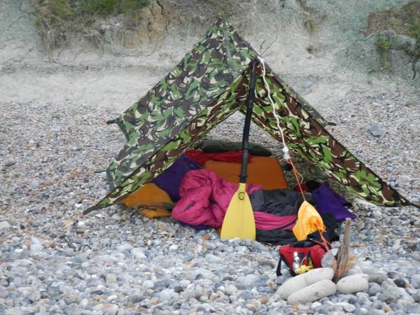
Tony's tarp
Apart from the two couples who were
disinterestedly watching a fishing rod, we had this side
of the beach to ourselves. We considered making a fire,
but a dearth of decent material and group lethargy when
it came to scouring the beach, decided it. It was
pleasantly mild anyway as we sat around watching the now
ghostly fleet making its way home. That night there were
probably ten large ships anchored off-shore and a couple
of them were so brightly illuminated that they could
have been cruise ships full of middle aged couples
partying into the night.
In order to take advantage of the tides,
we left about 07:45 the next morning. Stew didn’t
complain too much, so I presumed that he had slept
reasonably well. There was a little more cloud cover
today and the sea was slight. The ledges were covered as
we were close to high water and we made good progress
along the coast to Ryde and landed on a gently shelving
sandy beach adjacent to the leisure harbour. Stew and I
decided to check out the local cafes, but we were
underwhelmed by what the town had to offer. Ryde Sand on
big tides dries out to about a mile offshore, so we had
to keep an eye on our boats.
The Island Sailing Club and the Royal Southern Yacht
Club try to meet up annually for a
cricket match on the
Bramble Bank on a big spring tide. The Bramble Bank is
approximately mid-way between Calshot and Cowes.
Occasionally the match is rained off or the pitch is
flooded. The next planned match is for September 11th
2014.
The wind, although light, had veered around to the NE as
we set off towards Spit Sand Fort. With the light breeze
in our face we expected to get a bit of spray in our
faces. For the first half a mile we were paddling in
water only a few feet deep. Our course took us east of
the ferry route between Portsmouth and Ryde, so although
we saw and heard many vessels, we were safely out of
harm’s way. We only saw one large ship heading our way
from Southampton and it passed safely in front of us
before we crossed the deep water channel. We probably
paddled over the site of the Mary Rose capsize as it is
about half a mile SSW of the fort. It took about an hour
to reach Spitbank Fort where we had a chocolate break. A
small motorboat was slowly going around the fort
dangling a couple of fishing rods. Perhaps we frightened
the fish, or possibly he was getting dizzy, but he
motored off soon after we arrived. There was now a short
hop to the red buoy marking the fairway for ships
leaving Portsmouth. After a quick look around for huge
cross channel ferries or warships bearing down on us,
and seeing nothing, we quickly crossed to the green
buoy.
We had another 4km of Southsea sea front to paddle. Just
after the pier we paddled over the anti-submarine
barrier that had been constructed just before the 2nd
World War. The barrier extends about two miles out and
finishes close to Horse Sand Fort. There are gaps that
allow small craft through. A little way after the
barrier, the Royal Marines Museum is housed in a
handsome Victorian building. Fort Cumberland was built
at Eastney Point to protect the entrance to Langstone
Harbour. It was built in 1746 as a pentagon. Our get-out
was roughly equidistant between the two buildings, but
as it was low tide and we were paddling close to the
beach, I missed some significant points of reference.
Ooopps. I was out by a couple of hundred yards, but the
walk warmed us up on this already very pleasant day.
Thanks to Stew, Carlos and Tudor for their company this
weekend, and apologies for the early start. “Tides
apparently wait for no man”.